Day Hiking in Glacier National Park

Old Man Lake

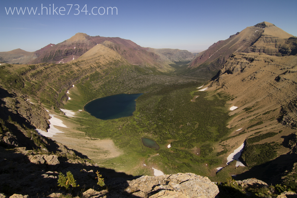
Glacier National Park is a day hiking paradise. Varied terrain from dense forests to dry, rocky slopes to alpine meadows, it never gets old. While you can’t reach all 734 miles of trail or see all 1 million+ acres in a day, you can see a large portion of it. Below are 88 day hikes that I’ve identified and ranked for my Day Hikes of Glacier National Park Map Guide.

Scroll down for a list of all of the day hikes or click over to my interactive map with links to blogs that I’ve published for every trail in the park!


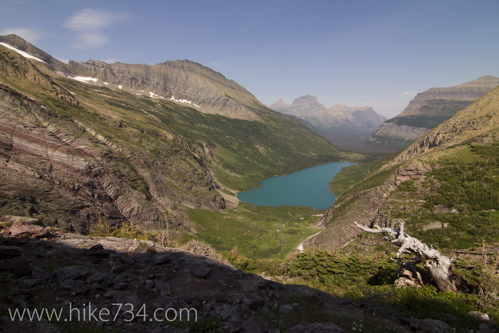
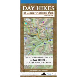
The ranking is my recommendation based upon what I feel gives you the most “bang for your buck” starting with the classic Highline Trail that embodies what make the Park so unique and wonderful. Click each trail name to learn more about the hike. All of this information and more is included in the Day Hikes of Glacier National Park Map Guide that I originally put out in the spring of 2014 (and have updated periodically since). It’s the best map for hiking in Glacier that includes distances between junctions and color coded trail segments denoting slope steepness and much more on one side and a guide on the back of the map. Pick one up to take with you on the trail!

Areas are as follows:
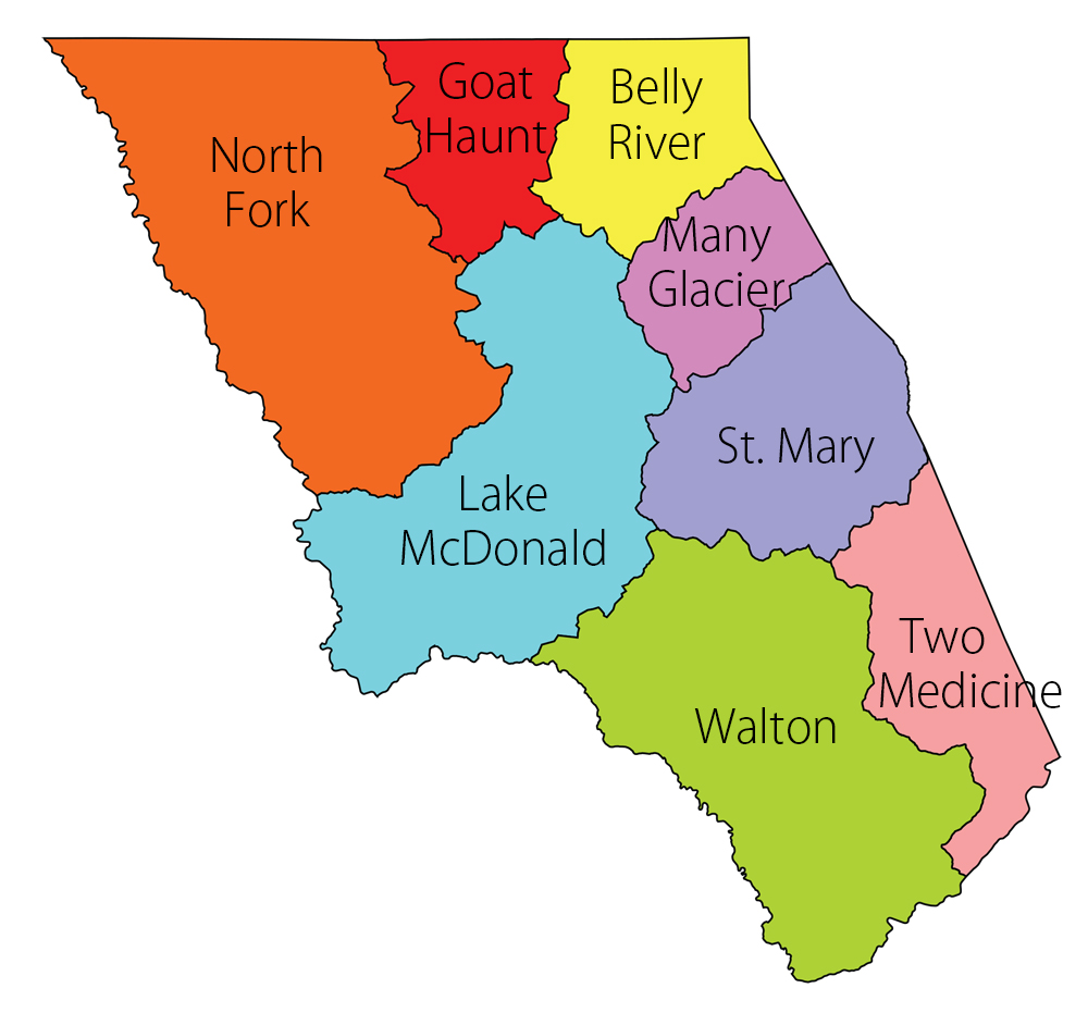
Glacier National Park Regions
Click to Enlarge
  • BR – Belly River
  • GH – Goat Haunt
  • LM – Lake McDonald
  • MG – Many Glacier
  • NF – North Fork
  • SM – St. Mary
  • TM – Two Medicine
  • WA – Walton

Click on table headers to sort by those columns!

Jake’s RankHike NameDistance GroupArea
1Highline Trail10-15LM
2Grinnell Glacier10-15MG
3Pitamakan / Dawson15+TM
4Iceberg Lake5-10MG
5Hidden Lake0-5SM
6Ptarmigan Tunnel10-15MG
7Siyeh Pass5-10SM
8Bullhead Lake5-10MG
9Fishercap Lake/Redrock Falls0-5MG
10St. Mary/Virginia Falls0-5SM
11Avalanche Lake0-5LM
12Swiftcurrent Pass10-15MG
13Firebrand Pass10-15TM
14Baring Falls0-5SM
15Dawson Pass5-10TM
16Gunsight Pass15+SM
17Scenic Point5-10TM
18Grinnell Lake5-10MG
19Piegan Pass5-10SM
20Lake Josephine0-5MG
21McDonald Creek0-5LM
22Rockwell Falls5-10TM
23Running Eagle Falls0-5TM
24Sun Point to St. Mary/Virginia Falls0-5SM
25Swiftcurrent Lookout10-15LM
26Trail of the Cedars0-5LM
27Lee Ridge10-15BR
28Cracker Lake10-15MG
29Triple Divide Pass10-15TM
30Otokomi Lake10-15SM
31Huckleberry Lookout10-15LM
32Beaver Pond0-5SM
33Apikuni Falls0-5MG
34Cobalt Lake10-15TM
35Florence Falls5-10SM
36Kootenai Lakes5-10GH
37Medicine Grizzly Lake10-15TM
38Mt. Brown Lookout5-10LM
39Upper Two Medicine Lake0-5TM
40Numa Ridge Lookout10-15NF
41Loneman Lookout10-15WA
42Hidden Meadow0-5NF
43Elk Mountain5-10WA
44Sperry Chalet / Sperry Glacier15+LM
45Harrison Lake10-15WA
46Gunsight Lake10-15SM
47Johns Lake Loop0-5LM
48Paradise Point0-5TM
49Swiftcurrent Nature Trail and Loop0-5MG
50Rising Sun0-5SM
51Rocky Point0-5LM
52Goat Lick0-5WA
53Belton Bridge0-5LM
54Apgar Lookout5-10LM
55Quartz Lake Loop10-15NF
56Snyder Lakes5-10LM
57Akokala Lake10-15NF
58Howe Lake0-5LM
59Aster Park Overlook0-5TM
60South Shore St. Mary Lake15+SM
61Avalanche Trail5-10LM
62McDonald Creek Loop0-5LM
63Flathead Ranger Station5-10LM
64Morning Star Lake10-15TM
65Apgar Bike Path0-5LM
66Autumn Creek5-10WA
67Covey Meadow0-5NF
68Rogers Meadow5-10LM
69Poia Lake10-15MG
70Scalplock Lookout5-10WA
71Two Medicine Lake5-10TM
72Logging Lake10-15NF
73Red Eagle Lake15+SM
74Rainbow Falls0-5GH
75South Boundary Trail10-15LM
76Trout Lake5-10LM
77Lake McDonald Trail5-10LM
78Waterton Overlook0-5GH
79Dutch Lakes15+NF
80Akokala Creek15+NF
81Quartz Creek10-15NF
82Coal-Fielding15+WA
83Fish Lake5-10LM
84North Fork Belly River15+BR
85Howe Ridge10-15LM
86Huckleberry Nature Trail0-5LM
87Lincoln Lake15+LM
88Snyder Ridge10-15LM