Your cart is currently empty!
East Rim Summits
East Rim Summits – 27mi / 43.4km

This one-way, epic day along the length of Zion’s East Rim hits all three summits that have a trail leading to them (Deertrap Mountain, Cable Mountain, and Observation Point). The views from the stops along the way, while similar, each have their unique perspective on Zion Canyon. A shuttle is needed to get you to the East Rim trailhead near the East Entrance and the Zion bus system can be taken back to your car at the Zion Visitor Center.
Starting on the East Rim Trail near the East Entrance of Zion, you travel along a broad trail through slickrock and desert shrubbery. The trail starts off fairly level with some soft, sandy spots along the way. The trail switchbacks at Cave Canyon and begins to climb. You wrap around the point that separates Cave Canyon and Jolley Gulch, with the latter being an impressive canyon. At almost three miles, the trail crosses Jolley Gulch. At the crossing, you stand on a rock slab that looks straight down into a writhing fissure. Years of water eating away at the sandstone have created a dramatic slot canyon to enjoy from a great vantage.
The wide trail continues to climb up onto the plateau. The contrast between the sandstone with desert brush and the ponderosa pine forest is fantastic as you move from valley floor to high perches. Views of the surrounding mountains are impressive and constantly changing.
Eventually, the trail traverses the plateau and heads in among stately ponderosa pines. It then drops down towards the intermittent Stave Spring. In this area, a sawmill once stood when the rim was logged and the timber was supplied to the canyon by the “draw works” at Cable Mountain. Follow the signs immediately after the spring to the left, heading west towards Deertrap and Cable Mountains.
The terrain opens up as you climb out of the ponderosa forest. After a little over a mile, the trail forks with Deertrap Mountain Trail heading off to the left. The trail goes up and down as it traverses the plateau. Grassland and shrubs dominate the landscape while intermittent views of surrounding mountains, cliffs, and valleys keep it from becoming mundane.
Eventually you reach the edge of the canyon wall and the views go from interesting to incredible. Right where the trail first comes to the edge of the cliff, you can look directly down onto Zion Lodge. Across the canyon are views of the Sand Bench Trail and the Emerald Pools. Peaks along the canyon rims are visible everywhere. Mountain of the Sun dominates your view at eye level, as well as the prominent rock features known as the Court of the Patriarchs.
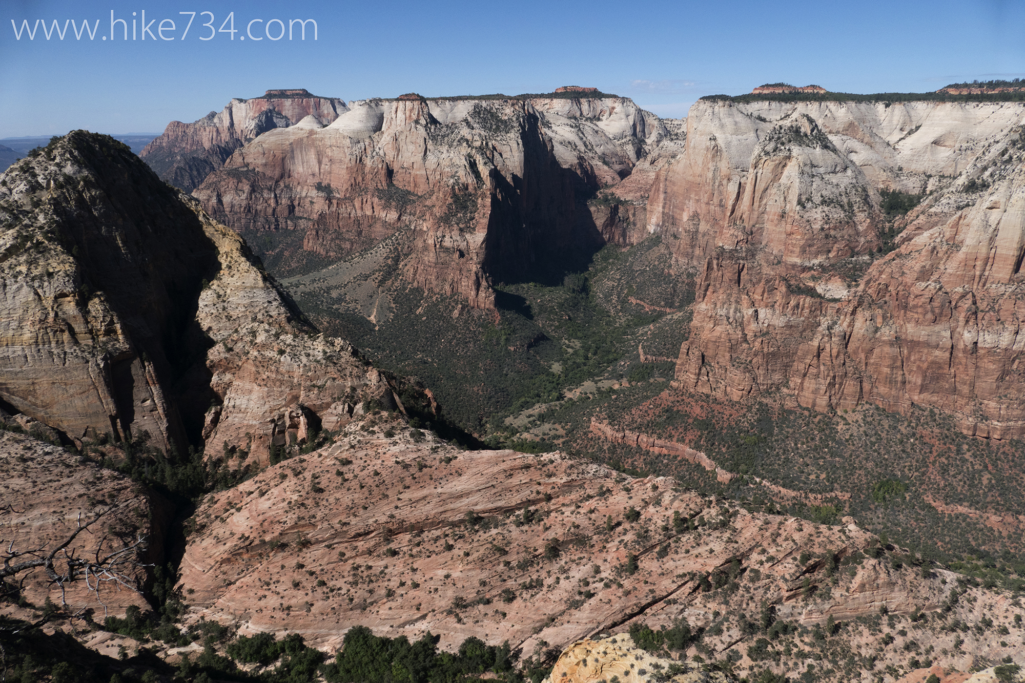
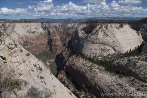
The trail continues to traverse along the ridge and ends in a clearing. The Great White Throne stands prominently with a distant view of Angels Landing.
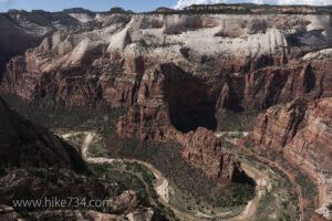
Follow the trail back to the junction with the Cable Mountain Trail and take the fork heading left to Cable Mountain. After a little more elevation gain, the trail drops. The trail ends at the cable structure and the precipitous rock edge of the canyon wall. Views are nothing short of breathtaking as you look across the valley and far to the north. Angels Landing rises prominently in front of you and the Zion Canyon road follows the Virgin River that snakes thousands of feet below you.
Head all the way back to the junction near Stave Spring and follow the East Rim Trail north towards Echo Canyon. You cross through a broad sagebrush meadow and to the steep cliff edge of one of the side canyons that leads down to Echo Canyon. (Note that the trail that comes in from the east in this sagebrush meadow is the trail from the Zion Ponderosa Ranch.) The trail follows along the steep, impressive walls leading to switchbacks down one of the faces to the bottom.
As you reach the bottom, trees impossibly spring up out of the slickrock. The trail dissolves on the hard sandstone surface. Pay attention to cairns, stacks of rocks, to guide you along the “trail”. After about a mile, traverse along the bottom of the canyon, the signed trail for Observation Point takes off to the right.
This section of trail, hewn from the rock, is a marvel of trail engineering. The switchbacks, visible from the bottom of Zion Canyon, take you steadily to the top of the rim. The views from this section of trail that hug the cliffs are nothing short of breathtaking and are not for those with a fear of heights.
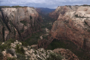
Once past the switchback section, the trail primarily follows the edge of the rim where it meets up with the East Mesa Trail and continues on to your destination of Observation Point. Even before you get to the end of the trail, fantastic views down to the Virgin River are exceptional as it comes out of the Narrows. At the actual point at the end of the trail, you see Angels Landing beneath you and further down the rest of Zion Canyon as it heads out to Springdale. At eye level are many of Zion’s signature summits such as Cable Mountain and The Great White Throne. From this point, turn around and head back down.
Back at the junction for the Observation Point Trail, take a right to head through the heart of Echo Canyon. The canyon narrows down and the walls almost completely close in overhead creating a tunnel of sorts. This section is a worthy destination in and of itself. This area can also become very dangerous in the event of flash flooding, so proper attention to the weather is paramount.
After the narrow part of the canyon, it opens up into a large area with high walls that makes it feel like you’re in a large room. The trail emerges from the narrow canyon and into a bend along the Virgin River in the main Zion Canyon that includes the Weeping Rock Trail. The paved trail switchbacks down to the Weeping Rock trailhead.
Trailhead: From Springdale, take Highway 9 east through the Zion-Mount Carmel Highway Tunnel. Make a left at the turnoff on the north side of the road just before the East Entrance. The trail starts at the gate at the end of the parking lot. Arrangements can be made in advance with one of the shuttle services in Springdale to take you to the trailhead. The trail ends at the Weeping Rock trailhead, allowing you to use the Park’s free shuttle back into Springdale.
Elevation Gain: 4,350ft / 1,305m – Elevation Loss: 5,675ft / 1,702m