
Your cart is currently empty!
Coal Nyack Loop
—
by
While most visitors to Glacier National Park stay around Going to the Sun Road with ventures to Many Glacier and Two Medicine, the furthest north and the furthest south tend to get the least amount of attention. Few places exemplify this more than the Coal Nyack region.
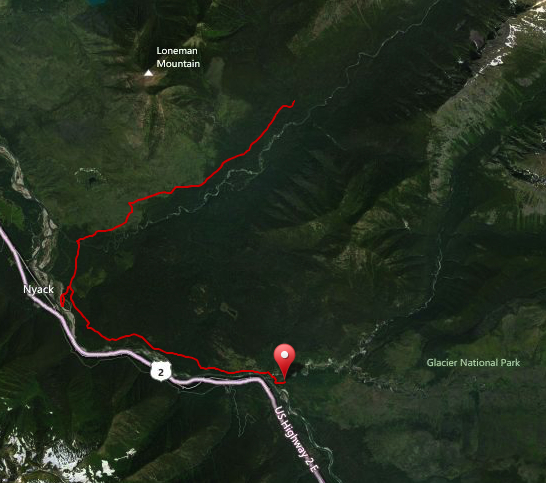
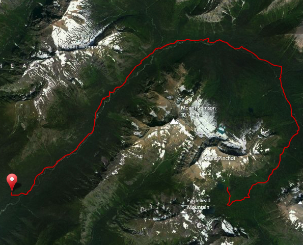
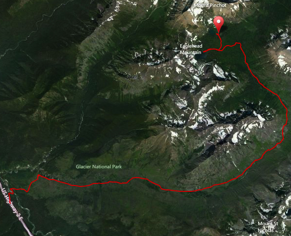
The Coal Nyack Loop is accessed either from the Nyack Creek trailhead or the Coal Creek trailhead. Either way requires a ford of the Middle Fork of the Flathead River. (in all fairness of disclosure, one could hike the south boundary trail to get to the Nyack trailhead, but logistics become silly) For this video, I went in at the Coal Creek trailhead, walked the south boundary trail, then up the Nyack Drainage to Surprise Pass and Martha’s Basin, then down through the Coal Creek drainage back to the car.
The loop has been left intentionally rugged. Any remaining bridges in the area were removed necessitating multiple creek crossings. Campsites are at a minimum and undesignated camping is the norm allowing for early 1900’s style flexibility. Few patrols and fewer visitors mean that isolation and wildness is the theme of the trip.
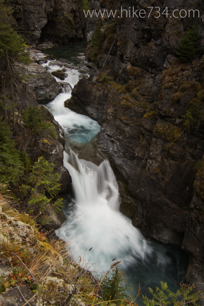
Most of the trip is spent in the trees with the exception of a small burn area a little ways in the Nyack, the subalpine areas of Martha’s Basin and a large share of the Coal Creek drainage due to a large fire that gutted the area of trees… and protection from the sun. Crown jewels are some of the early sections of the Nyack as it cascades through canyons, solitude, Beaver Woman and Buffalo Woman lakes and the fantastically rugged peaks you get to view as you move through the Coal region. Windows to peaks along the hike and just being close to the creeks are also great bonuses and really set this part of the Park away as a unique backpacking experience compared to the rest of the park.
If you’re looking for a multiple day backpacking trip in solitude with some real gems scattered among trees and water crossings, the Coal Nyack Loop might be right up your alley.

coal creek coal nyack glacier Glacier National Park going-to-the-sun road hike many glacier middle fork nyack creek south boundary trail surprise pass the loop two medicine
Comments
13 responses to “Coal Nyack Loop”
-
Man, that cabin at the end looks pretty cool. Ive found my dream home! haha
Definitely want to go up there sometime, maybe after the waters recede a bit.-
For sure! One of the few cabins that are unlocked… although I’d venture to guess that the others look a little bit more “habitable” than this one. It kinda breaks my hear that they aren’t doing anything to preserve it…. boo!
-
-
How was the trail for you? Accounts of the route indicate that the trail is hard to follow in places. Did you find that to be the case (or not)? Did you encounter a lot of downed trees? Did trail conditions and obstacles slow your progress, or did you get through reasonably well? How many days did you spend there?
Thanks.
-
The trail does get overgrown in spots, but I wouldn’t think that you’d lose your way at all. Downfall depends upon the time of year. Later in the year is always better for downfall and creek levels. There are no bridges in that loop, so every creek crossing is through the water.
I did it in three days as I had friends on horseback that carried my overnight gear so I was basically day-packing. I think four days is a sweet spot… that is if you do the full loop. You can shorten it by taking out the South Boundary Trail and making it more of a horse-shoe shape by going in Nyack and finishing by the Coal ford.
-
-
I don’t understand the two trailheads / parking areas you’re talking about – looking at google earth, not only is there no bridges across the middle fork anywhere near the Coal/M.F. convergence or Nyack/ M.F. convergence, there are no parking areas to be seen, either….. what gives? The official map shows no such trailhead parking areas either: http://www.nps.gov/glac/index.htm
-
You won’t find any bridges down there! That area has been returned to a more rustic area with no bridges and such, so you have to do river and creek fords. The parking area for Coal Creek is basically in the trees on the south side of the road with a stock loading ramp and a hitching post. If you go down the road a bit to the Stanton Mtn trailhead (which is on the Forest Service side), there is a bigger parking lot. As far as the Nyack, that ford is down a road by the railroad tracks where you park. Then it’s a matter with both of them to apply good fording practices such as right above the riffles with appropriate poles and such to keep you balance. Also, make sure you’re crossing when the water is safer, not in the spring when the river is an angry beast. 😉
-
-
Hey, thanks for the great post ! For this loop, do you just need a walk in permit, or do you still need to apply for a reservation? I’m new to the whole National Park permit thing. Thanks again!
-
If you plan on staying at designated camping sites during the busy season, then getting an advanced permit would probably be the way to go, however, this year, Upper Nyack campsite is closed, so you would need to do an undesignated camping site anyway. You’ll just need to do a walk-in permit.
-
I did part of this hike last year (2016) in June, as part of a traverse from Essex to West Glacier along the South Boundary Trail. At that time, the section between Coal Creek and Nyak Creek was very overgrown in parts and sort of made us lose the trail. I believe it was about 1-1.5 miles south of where the trail crosses Nyack Creek. The trail gradually became more and more overgrown with thimbleberry bushes and the like, including some significant blowdowns, until it appeared we were no longer on it. Finally found the trail again near the dilapidated cabin in the end of your video, which I guess is near the intersection of where the Nyack Crossing Trail hits the South Boundary Trail? Tough to describe but we also saw some orange ribbons and open areas but they were not the trail and confused us further. I would advise anyone hiking that portion to be particularly alert for staying on the trail.
-
Good reminder! You visited it in a particularly tough year because the fire made the efforts for trail crew more difficult. That stretch of trail gets less maintenance earlier in the year as well because the crews cross the river and they have to wait until the river goes down. Thanks for the heads up!
-
-
Anybody know what the condition of the trail is these days from Upper Nyack to the Middle Fork along Nyack? I am wondering if it is just a hopeless mess of fallen trees from the fire in 2015. Considering trying to hike from East Glacier to West Glacier by passing that way.
-
Can you please tell me the mile marker for US2 where the coal creek crossing is for the trailhead? I know Nyack crossing is 164-164 and Walton is ~181, but I can’t find the info for where to park/start the coal creek crossing. We are going to do a long day hike from coal creek to Walton and would like to know where the start is for coal creek. thanks!
-
I’m not sure what the mile marker is. I’ll email you a link in google maps. 😀
-
Leave a Reply