Your cart is currently empty!
Dunanda Falls

Dunanda Falls – 16.9mi / 27.2km

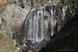
This fantastic waterfall drops 110ft/33m over a cliff as Boundary Creek works its way to the meadows below. Take the Bechler Meadows Trail that begins at the Bechler Ranger Station. At 1.6mi/2.6km, take a left at the trail junction and follow the Boundary Creek Trail which stays on the little ridge above the meadows.
The first 3.9mi/6.2km of this hike are on a level trail through a lodgepole forest with a few scattered views to smaller meadows. After a ford of Bartlett Slough, the trail enters the meadows, where various sections may be marshy depending on the time of year. The trail follows the edge of the forest, occasionally traveling through it for short sections.
Eventually you get to a ford of the slow moving Boundary Creek. Check with the rangers for current conditions, especially before mid-July. (The fording of the creek can be avoided by taking the longer route through Bechler Meadows using the Bechler Meadows Cutoff Trail which is discussed later.) Once across the creek, the trail continues through meadows with a view of the Teton Range to the south. The trail enters a nice riparian area, loosely following Boundary Creek upstream, all the while dipping in and out of trees. It then follows an unnamed tributary of Boundary Creek before crossing through a meadow.
The trail fords this tributary the first of three times, but should be navigable over logs. As the trail gains elevation, the trail passes through a patchwork of lodgepole stands and open meadows. The final two stream crossings happen as you gain elevation; one having a footbridge while the other may need fording. For now, pass the spur trail for Dunanda Falls and continue for approximately 100yd/90m to see Silver Scarf Falls. Return back to the junction and follow the spur trail up to Dunanda Falls.
Boundary Creek plummets 110ft/33m straight down in a curtain, crashing on boulders below. The view is a bit obstructed, but the trail goes to the top of the falls. Turn around and head back. An alternate route to the falls, which avoids the fording of Boundary Creek, stays on the Bechler Meadow Trail to the junction with the Bechler Meadow Cutoff Trail. The Bechler Meadow Cutoff Trail leads to the Boundary Creek trail. This route is 0.6mi/0.9km longer each way. It spends more time in open meadows, away from Boundary Creek, but is similarly level. It’s also a nice route to take on the way back for variety.
Trailhead: Take the Cave Falls Road from Ashton, ID. Take a left at the sign for the ranger station. The trailhead is located between the ranger station and the corral.
Elevation Gain: 550ft / 165m – Elevation Loss: 550ft / 165m


