
For over two decades we have been a trusted expert of hiking in the national parks. Our company’s website and products provide valuable trip planning and hiking resources.
Trust & Expertise

We know that it can be logistically overwhelming to plan hiking trips in the national parks, and there’s a lot of confusing information out there to sift through.
That’s why we built this resource-rich website, created our all-in-one Map Guides and helpful apps, and continue to share valuable hiking insights and information with fellow hikers.
We hike every trail that we list on our guides, so you know you are getting first-hand knowledge and recommendations.
After hiking all the trails, Jake compares them based on scenery, uniqueness, features, trail experience, and overall reward for effort. The rankings reflect real, boots-on-the-ground experience, not crowdsourced opinions.
Most hiking resources include trails without context or ranking. Additionally, apps generally rely on crowdsourced data and opinions.
Hike 734 focuses exclusively on day hikes in specific national parks. We personally hike the trails so we can write first-hand trail descriptions and provide honest rankings and recommendations.
Hike 734 Products:
Day Hike Map Guides
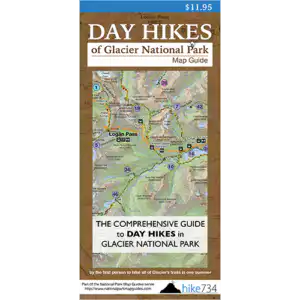
It’s more than just a map! It’s an all-in-one planning and hiking tool designed to help you choose the best hikes quickly and confidently.
Each Hike 734 Map Guide combines a detailed, easy-to-read topographic map with concise trail descriptions, distance, elevation gain, steepness indicators, and Jake’s full ranking of every day hike. You’ll find the hikes that are right for you and know which ones are worth your time and energy.
It’s made by hikers, for hikers!
They’re ideal for:
– First-time visitors who feel overwhelmed
– Families and/or friends planning together
– Visitors with limited time
– Hikers who want a big-picture overview
– Anyone who prefers a waterproof, battery-free tool
– Those who enjoy using a physical product rather than a screen
Many customers use it before their trip to compare hikes, choose routes, understand the layout of the park, and plan where to stay. It’s designed to simplify planning and help eliminate the guesswork and overwhelm of visiting a new place.
Yes.
Each Map Guide includes a list of day hikes trails that are recognized by the park service (social trails and most off-trail routes are not included).
Jake has hiked all of the listed trails on each Map Guide and provides valuable insight and information about each hike.
Yes.
It’s printed on a lightweight, tear-resistant synthetic material that can withstand all trail conditions.
Orders are shipped via USPS First Class mail and most orders take 6-9 days for deliver.
If you need your order to arrive sooner, select a different option at checkout or contact us to make specific requests.
Note: Most Airbnbs, VRBOs, and short-term rentals usually don’t accept mail deliveries for their customers. Contact us to discuss alternative options.
These parks are home to abundant hiking trails, and visitors are often faced with overwhelm and confusion when trying to determine which hikes are worth their time and effort. While other national parks do have incredible hiking trails, we have identified as these seven as our top hiking destinations.
Day Hike Apps
It includes Jake’s ranked day hikes, trail descriptions, and navigational tools all in a simple, easy-to-use digital format.
No.
Many hikers use both for convince and quick reference. And for some it just boils down to personal preference.
The map for big-picture clarity and planning
The app for on-trail navigation
Both products will help you find the best hikes to meet your ability, time, and expectations.
Yes.
Once downloaded, hike details and navigational tools can be accessed even when service is limited or unavailable.
The app is best if you:
– Prefer digital tools
– Like to search for hikes by filterable features
– Enjoy using GPS navigation
Yes! And many hikers do.
Together they create a “complete planning and navigation toolkit”.
Day Hikes of Glacier National Park is the first app released by Hike 734. Stay tuned as others become available in the App Store or Google Play.
Download the app from Apple App Store or Google Play using the links below.


GOING-TO-THE-SUN ROAD DRIVING & BIKING GUIDE
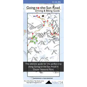
Yes, especially if you only have one day.
The road covers a long distance with many potential stops. This guide helps you prioritize the most scenic and worthwhile locations so you don’t waste time guessing.
The official park map shows the general route and touches on basic park information.
This guide provides added detail and curated insight. You’ll know exactly which stops are most scenic and how to structure your drive or ride efficiently.
Many visitors find both the Day Hike Map Guide and the GTTS Road Map Guide very useful regardless of their intended or confirmed itinerary. You can purchase this bundle as the “Day Trippers Package”.
GPS Tracks
The GPS track download is perfect for those who want to upload the trail data to their favorite GSP device or mapping application.
No.
The file only contains GPS trail tracks. Jake’s trail ranking and descriptions are not included with this purchase.
Common Questions from Hikers:
Printed vs digital App
There’s no wrong choice. It might just come down to personal preference.
The App is great if you:
– Prefer digital tools
– Like to search for hikes by filterable features
– Enjoy using GPS navigation
The physical Map Guide is ideal if you:
– Want to see the entire park at once
– Prefer a large-format visual overview
– Want a waterproof, battery-free navigation tool
– Like planning with family or friends around the table or campfire
– Enjoy using a physical product rather than a screen
– Want a reliable backup resource (especially in remote areas of the park)
But if you’re still not sure, try both! You’ll discover how you prefer to plan and navigate hiking in the national parks.
Both are built from the same trail research and ranking system by Jake, but they’re presented differently. Both serve the same purpose in helping you find the best trails for your ability, time, and expectations.
Yes.
Both are updated to keep information as accurate and useful as possible.
Planning
Absolutely!
Whether it’s your first time visiting the park or you’re just looking for a new trail to explore, these tools will help eliminate the guesswork and make the most of your limited vacation time.
If you’re looking for the best hiking trails or just daydreaming about your next vacation, you’ll find lots of helpful and inspiring information throughout our website.
Each national park has its own peak-visitation periods and this varies by location and season. Optimal times to visit can be determined by typical weather conditions and the activities that are available during certain time periods.
Most high-elevation hiking is best during late-summer and into early fall. But that doesn’t mean that all hiking is off limits until the snow melts. Often, low-elevation trails can be explored year-round, even in the early springtime or during the winter months.
PRO TIP: Always be prepared for all types of weather conditions regardless of what time of the year you visit.