
Olympic National Park, described as “three parks in one”, can take you from the rocky shores of the Pacific Ocean, to lush rainforests, to windswept alpine areas— it’s varied, gorgeous, and enormous.
But with the regions spread so far apart, and no single road connecting everything, planning hikes across this diverse landscapes can be confusing and logistically challenging.
- Which hikes are right for me?
- What regions should I explore?
- How do I get to the trailhead?
Plan, hike & explore with confidence
Olympic is unique in that few other national parks offer such diversity of landscape— and we’re here to help you make the most of every moment.
Whether you’re here for a day or a full week, these planning resources will help you choose the right hikes and navigate the park with confidence.
We’re here to help!
Jake’s ranking of every day hike
After hiking the trails in Olympic, Jake created a ranked list of every day hike. The ranking system is based upon which hikes Jake feels will give you the most “bang for your buck” — starting with the breathtaking view from Klahhane Ridge.
Use the table below to learn more about the park regions and corresponding hikes.
Trip reports & trail videos
See what the hikes actually look and feel like. Our Olympic trip reports and videos show trail conditions, scenery, and what to expect before you step foot on the trail.
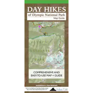
Day hike Map guide
Your all-in-one planning and hiking resource!
All the visual information of a topographic map paired with expert recommendations and all the trail and park specific details of a guidebook — it’s waterproof, lightweight and fits into any backpack.
Regions of Olympic National Park:
- North Olympic Coast
- South Olympic Coast
- Northwest
- North Temperate Rainforest
- North
- South Temperate Rainforest
- Southeast
- East
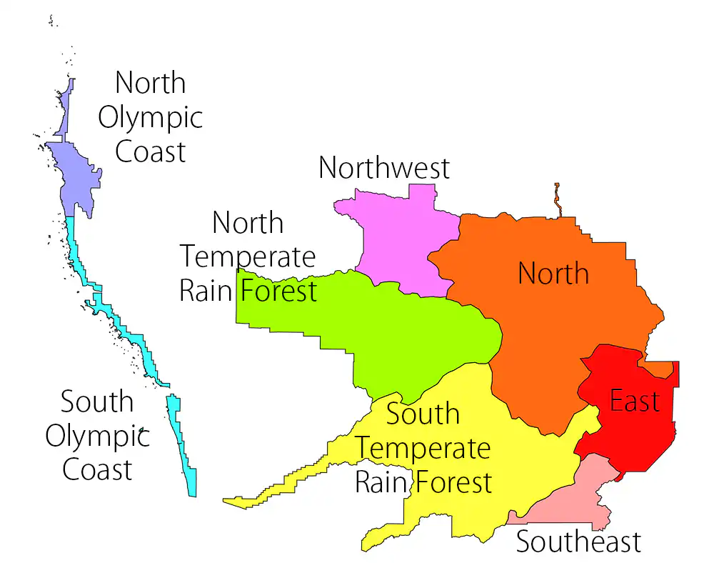
Note: All of this information and more is included in the Day Hikes of Olympic National Park Map Guide — make sure you have it in your backpack when you hit the trail!
- Click each trail name to learn more about the hike
- Click on table headers to sort by that column
Jake’s Rank Hike Name Distance Group Area 1 Hurricane Ridge to Klahhane Ridge 5-10 North 2 Grand Ridge 5-10 North 3 High Divide Loop 15+ Northwest 4 Royal Basin 10-15 North 5 Grand Valley Loop 5-10 North 6 Cape Alava and Wedding Rocks 5-10 North Olympic Coast 7 Rialto Beach/Hole in the Wall 0-5 South Olympic Coast 8 Hoh River Trail 10-15 North Temperate Rain Forest 9 Second Beach 0-5 South Olympic Coast 10 Switchback Trail 0-5 North 11 Lake of the Angels 5-10 East 12 Sol Duc Falls 0-5 Northwest 13 Shi Shi Beach 5-10 North Olympic Coast 14 Lena Lakes 10-15 East 15 Appleton Pass and Oyster Lake 15+ North 16 Queets River 10-15 South Temperate Rain Forest 17 Heather Park 5-10 North 18 Madison Falls 0-5 North 19 Sand Point Trail 5-10 North Olympic Coast 20 Marymere Falls 0-5 Northwest 21 Hall of Mosses Trail 0-5 North Temperate Rain Forest 22 Ruby Beach 0-5 South Olympic Coast 23 Geyser Valley Loop 5-10 North 24 Pony Bridge 5-10 South Temperate Rain Forest 25 Spruce Nature Trail 0-5 North Temperate Rain Forest 26 Browns Point 0-5 South Olympic Coast 27 Mount Storm King 0-5 Northwest 28 Third Beach 0-5 South Olympic Coast 29 Hurricane Hill 0-5 North 30 Flapjack Lakes 15+ Southeast 31 Wynoochee Pass and Lake Sundown 10-15 Southeast 32 Meadow Loop Trails 0-5 North 33 Beach 4 0-5 South Olympic Coast 34 Moments in Time Nature Trail 0-5 Northwest 35 Kestner Homestead Trail 0-5 South Temperate Rain Forest 36 Oil City Trail 0-5 South Olympic Coast 37 Maple Glade Trail 0-5 South Temperate Rain Forest 38 Sam’s River Loop 0-5 South Temperate Rain Forest 39 Rainshadow Loop 0-5 North 40 Little River Trail 5-10 North 41 Staircase Rapids Loop 0-5 Southeast 42 North Fork Quinault River 10-15 South Temperate Rain Forest 43 North Fork Sol Duc River 10-15 Northwest 44 South Fork Hoh River 5-10 North Temperate Rain Forest 45 Bogachiel River 10-15 North Temperate Rain Forest 46 Graves Creek 5-10 South Temperate Rain Forest 47 Deer Lake 5-10 Northwest 48 Lake Angeles 5-10 North 49 Boulder Lake 10-15 North 50 West Elwha Trail 0-5 North 51 Three Forks 5-10 North 52 Deer Ridge 10-15 North 53 Low Divide 10-15 Northwest 54 Glines Canyon 0-5 North 55 Dosewallips River Road 10-15 East 56 Spruce Railroad Trail 5-10 Northwest 57 Griff Creek Trail 5-10 North 58 Three Lakes 10-15 South Temperate Rain Forest 59 Aurora Ridge and Eagle Lakes 10-15 Northwest 60 Happy Lake 10-15 North 61 Pyramid Mountain 5-10 Northwest 62 Barnes Creek 10-15 Northwest 63 Big Log Camp 10-15 Southeast 64 PJ Lake 0-5 North 65 Mink Lake 5-10 Northwest 66 Aurora Creek and Sourdough Mountain 10-15 Northwest 67 Irely Lake 0-5 South Temperate Rain Forest 68 Peabody Creek Trail 5-10 North 69 Shady Lane Nature Trail 0-5 Southeast 70 South Snider – Jackson Trail 10-15 North Temperate Rain Forest 71 Olympic Hot Springs 5-10 North 72 Living Forest Trail 0-5 North 73 James Pond 0-5 South Olympic Coast 74 Cascading Terraces Trail 0-5 South Temperate Rain Forest 75 Kalaloch Nature Trail 0-5 South Olympic Coast 76 Lover’s Lane Loop 5-10 Northwest 77 Smokey Bottom Trail 0-5 North 78 Hurricane Hill from Elwha 10-15 North 79 Cascade Rock Trail 0-5 North 80 Heart O’ the Forest Trail 0-5 North 81 Fairholme Campground Trail 0-5 Northwest 82 Wagonwheel Lake 5-10 Southeast 83 Ancient Groves Nature Trail 0-5 Northwest 84 Quillayute River Slough 0-5 South Olympic Coast