Dutch Town – 12.3mi / 9.7km
Dutch Town was an old mining community that sat below a jaw-dropping bowl located in the volcanic moonscape of the Never Summer Mountains.
The trail begins as an easy stroll along the Colorado River, passing pocket meadows along the way. After 0.5mi/0.8km, follow the signs left and cross over the river where you’ll begin to climb. As you pass through a large boulder field, keep a lookout for pikas at your feet and elk and moose in the Kawuneeche Valley meadows below.
The trail turns into the forest and passes through the amusingly named “Hells Hip Pocket”. The Never Summer Mountains briefly come into view. You’ll drop down, crossing Opposition Creek, then climb up to the Big Ditch, a water diversion channel. Take a right on the service road and follow it north alongside the flowing water. A string of mountains are visible across the valley to the east. Below, some of the valley’s notable features such as the Shipler Mine and Little Yellowstone can be spotted as you look north towards La Poudre Pass.
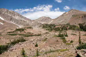
After 1.7mi/2.8km on the road, a log footbridge over the ditch takes you off the road and onto the trail up towards Dutch Town. You’ll climb the lovely subalpine forest as you follow along Big Dutch Creek passing faint remnants of the old community. The crumbling ridge of Howard Mountain sharply rises on the south side of the creek. Follow the steep trail up past the campsites where you’ll emerge from the trees and into a wet meadow. Lead Mountain rises in the distance and gives you a taste of views to come. Past the meadow, the trail scrambles up to the rocky moonscape. The massive hulks of Howard Mountain, Mount Cirrus, and Lead Mountain create an expansive bowl. The entire landscape is strewn with boulders. A waterfall cascades down from Lake of the Clouds.
For those looking for a little extra, a scramble up to the right of the waterfall leads to this crystal lake tucked high amongst the rubble.
Trailhead: Turn into the signed Colorado River Trailhead parking area 9.5mi/15.2km north of the Grand Lake Entrance off the Trail Ridge Road.
Elevation Gain: 1,950ft / 585m – Elevation Loss: 1,950ft / 585m