Shadow Mountain Lookout – 10.2mi / 16.5km
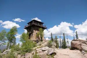
Enjoy expansive views of the Grand Lake area at this fortress of a fire lookout.
You’ll begin by cruising through a sagebrush meadow near the Green Ridge Campground. The trail comes alongside the Colorado River at the outlet of Shadow Mountain Lake. Here, you’ll cross over the dam with gorgeous views of the lake.
The trail follows along the shoreline of the lake with ample views. While some of the trees in the forest are still green, beetles have largely turned the forest into standing sticks. Stay straight through the junction that heads south towards Lake Granby. The Shadow Mountain Trail breaks off to the right shortly after.
The trail leaves the easy going of the lakeshore and begins climbing through the lodgepole forest. As you climb higher up on the moraine, you get filtered views of the lake below. The trail turns sharply, crossing a gully, then wrapping around rock outcroppings with great formations. Views open to the south before disappearing as you enter back into the trees. Just below the lookout, the trail begins switchbacking up at a steeper grade for the last 450ft/135m to the top. Just before the lookout, you get some views looking down on Grand Lake.
The aging lookout tower itself is no longer accessible but views looking down into the valleys below and across to the various mountain ranges are still wonderful. On the way back, consider exploring Ranger Meadows (see Ranger Meadows Loop for description).
An alternate route from the East Shore Trailhead follows along Shadow Mountain Lake from the town of Grand Lake offering abundant lake views as well. While about the same length, it adds an additional 120ft/36m elevation change each way.
Trailhead: At the south end of Shadow Mountain Lake, turn east onto County Road 66 to Green Ridge Campground. Follow the road past the campground and onto the gravel road to the trailhead. For the East Shore Trailhead, turn onto West Portal Road from Hwy 36 to Grand Lake. Take a right onto Center Drive and follow the signs to the trailhead.
Elevation Gain: 1,600ft / 480m – Elevation Loss: 1,600ft / 480m