Atsina Lake

Stoney Indian Pass

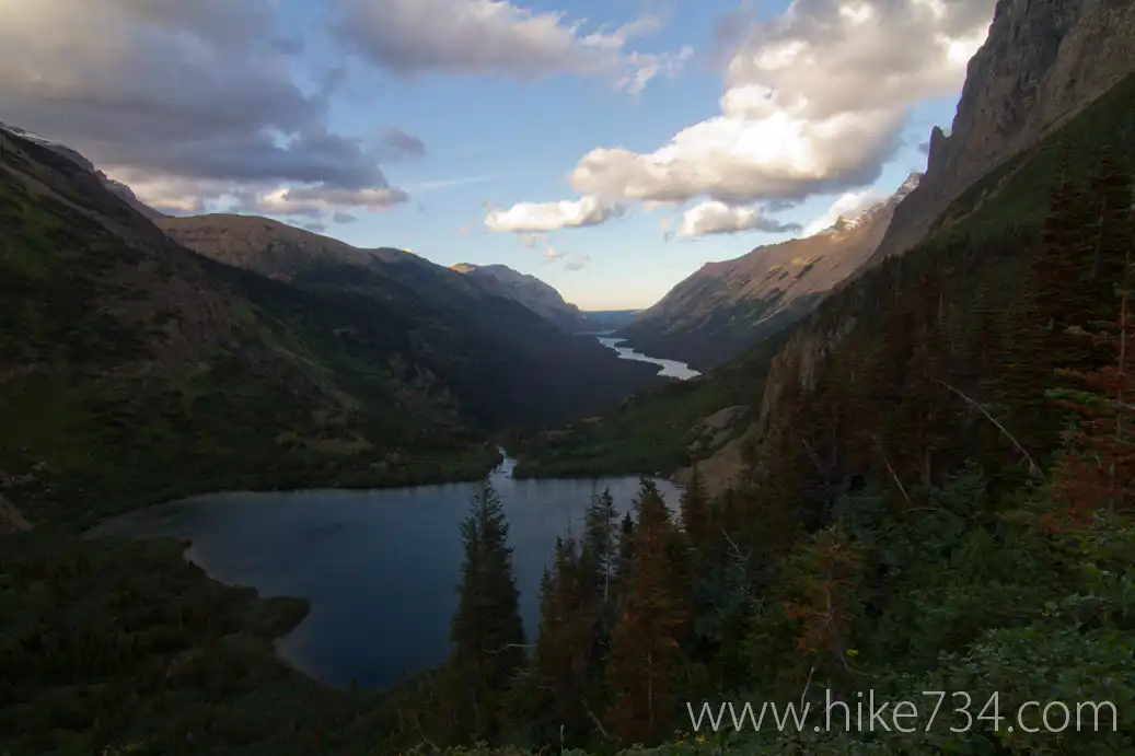
The Belly River area in Glacier National Park offers numerous rewarding backpacking experiences. The Belly River drainage heads up to Elizabeth Lake, passing the powerful Dawn Mist Falls. The trail passes right above the falls and gives you a great look down while a spur trail lets you see them from the bottom and get a little misted. Elizabeth Lake is beautiful and serves as a junction for Ptarmigan and Redgap Passes heading over to the Many Glacier area. A walk along the west shore of Elizabeth Lake is gorgeous and towards the head of the lake, you’ll come to its second campground. Beyond that, and at trail’s end, you’ll come to Helen Lake with it’s cathedral walls and view up to Ahern Pass.

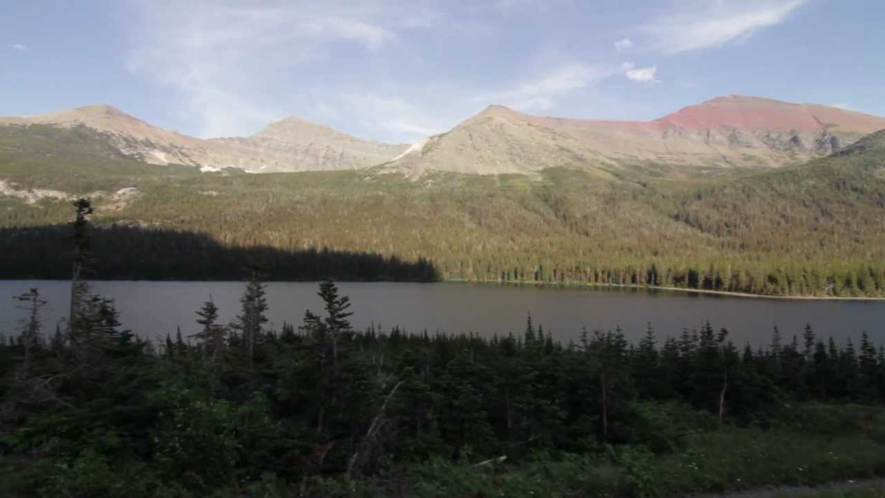
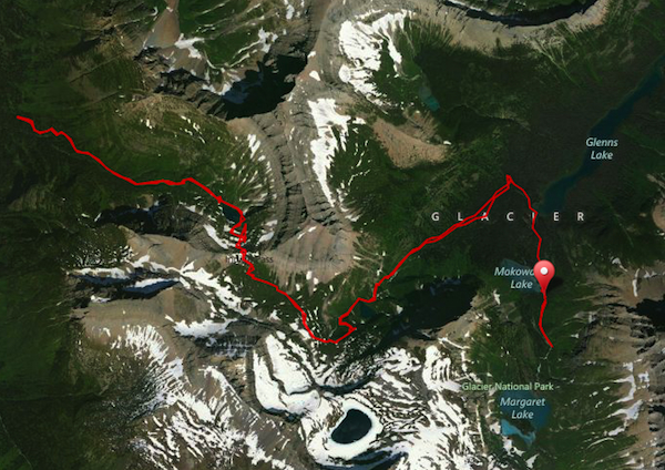
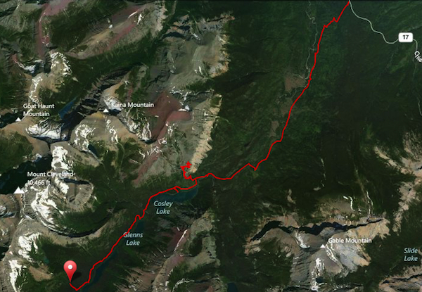
Heading back past Elizabeth Lake, around Cosley Ridge and to the west, you will find the Mokowanis drainage heading up towards Stoney Indian Pass. A mellow ford of Cosley Lake and you begin walking parallel to lakes for miles. (The ford is only for those coming to/from Elizabeth Lake. A bridge awaits those coming directly from the Belly River Ranger Station) First lake is Cosley with its campground, then the much larger Glenns Lake with its two campgrounds. A third lake nestled up the valley at the base of Pyramid Peak is Mokowanis Lake with its own quaint, two site campground. A beautiful waterfall is on the other side of a poorly maintained trail, but worth the quarter mile-ish effort.

After the Mokowanis Lake junction, you begin ascending through the trees and very quickly, you break through to get a bird’s eye view of the valley you were just in. You follow Mokowanis River up to its headwaters which is essentially a collection of small lakes with streams and waterfalls connecting them. Each level affords greater views and more waterfalls until you end up in a high alpine basin.

You continue climbing until you reach Stoney Indian Pass with views down towards the Waterton valley. Stoney Indian Lake is nestled into the mountains immediately below you and a few switchbacks and you descend 600 feet to the lake. At the foot of the lake lies the campground with the tent sites on the south side of the trail and the food prep on the north in a little alpine treed area.

Past the camp, you follow Pass Creek down to the Waterton Valley Trail. This quickly changes to alders and you then get swallowed up in trees as you descend to the valley bottom where you can go north to Kootenai Lakes, Goat Haunt and Waterton Lake or you can go south and head on up along the North Highline trail.

Heading back up and over Stoney Indian Pass and past the lakes previously mentioned, you come to a little spur trail for Bear Mountain Overlook. The site of an old lookout, Bear Mountain Overlook gives you an incredible “bird’s eye view” of the Belly River area. You can see into Canada to the north, look down onto the Belly River Ranger Station and over that to Chief Mountain and Gable Mountain. To the south you have Cosley Lake in the shadow of Cosley Ridge and to the west you have the rest of the Mokowanis drainage.

On the way back to the Belly River Ranger Station, you have a little spur down to Gros Ventre Falls which has falls coming down to a very pretty pool of water.

Overall, this area is amazing if you like lakes, rivers, streams, waterfalls and amazing basins surrounded by towering peaks.
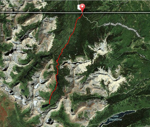
To Helen Lake
Stoney Indian Pass

From Helen Lake to Mokowanis Lake
Stoney Indian Pass

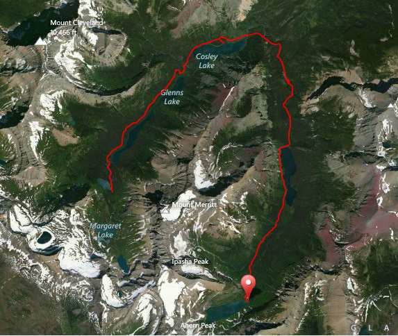
From Mokowanis Lake over Stoney Indian Pass and back again
Stoney Indian Pass

From Mokowanis Junction out to Chief Mountain trailhead with Bear Mtn Overlook
Stoney Indian Pass

Aspen Grove

Get our sweet newsletter!

(and your free “10 Insider Tips for Glacier”)

Lists

Comments

20 responses to “Stoney Indian Pass”

  1. Kevin B. Avatar
    Kevin B.

    Dang. I feel like I’ve said this 20 times already, but man, that whole valley just looks really awesome! Ive watched this one three times in a row, and still not tired of it.

    I’m starting to realize that my “must-do” list is pretty much becoming the whole park. haha

    1. hike734 Avatar
      hike734

      Nice!! Well, this is definitely an area that needs to be explored. I’m currently reading about Joe Cosley and Joe Heimes (who was the ranger who arrested him) and they both loved the Belly River area for some of the same reasons we do… remote, peaceful, breathtaking and ridiculously beautiful!

  2. Mike Kinsella Avatar
    Mike Kinsella

    Dawn Mist Falls may be my favorite waterfall in Glacier just because it takes so much work to see it- 12 miles from one trailhead and 8 miles from the other.

    1. hike734 Avatar
      hike734

      Well and it is soooo powerful! I like places like this that you can just sit there and enjoy without the crowds too. 😉

  3. Mark Hufstetler Avatar
    Mark Hufstetler

    Great stuff, as always!

    Bear Mountain, BTW, was the site of an old fire lookout that was removed many years ago … that’s why the trail’s up there.

    1. hike734 Avatar
      hike734

      Thanks for the head’s up! There are a few of these old sites such as Elk Mountain. Some still have trails, while others such as the Reynolds Lookout don’t. One thing that can be guaranteed about an old lookout site (or current ones for that matter) is that the view will be ridiculous. 😀

  4. Lindley Avatar

    Well Jake, I am impressed. I have not yet gotten to really take a look at your site, and I can honestly say it has helped me out more than any other “google search”. I am taking a group of 9 girls from the Summit Prep School up the Belly River on a challenge trip, and am trying to get some specific details of where we are going and where we will camp over the 4 days. Any help and direction from you would be much appreciated! Thanks Jake!!!

  5. Hi Jake! I’m planning a trip to Glacier in Sept. and would like to hike a bit in the Belly River area. The trail I was looking at starts at Chief Mountain Customs. I’d like to just do a day hike, maybe from customs to the ranger station. Do you have any idea where I could park the car? I can’t seem to find any definitive info on the web. Thanks!

    1. A couple of things. Their is a parking lot right before the border. You’ll be good. That being said, if you’re looking for a sweet day hike in that area, you should do Lee Ridge. If you want to see the ranger station too, you can do it as a loop, otherwise, you can do it as an out and back. The trailhead for Lee Ridge is about 1/4 mile from the border. There is a sign notifying you that the border is coming up in 1/4 (or 1/2) mile and there is a slow vehicle pullout. Look to the left and you’ll see a trailhead there. You can park there or, if you’re doing the loop, you can park at the other trailhead. Either way, I’d start hiking Lee Ridge first. Check the blog post here (you’ll only be doing the Lee Ridge to Gable Pass, not down to Slide Lake): https://hike734.com/trip/lee-ridge-gable-pass-slide-lake/

  6. Kristen Avatar

    Im in the midst of trying to hike the northern circle. My advance reservation got denied and it looks like STO and KOO are closed at the moment due to “environmental conditions” I’ve still got my fingers crossed for a walk in permit (aiming for M-F) Any idea if campgrounds that are closed open up during the same season? Obviously no one can predict the future but what might be the average time of campground closure.. … hummmm ..

    And thank you so much for this site !!! really answered so many of my questions. I cant wait

    1. Jacob Bramante Avatar
      Jacob Bramante

      Sorry I didn’t get to this earlier. What did you end up doing?

  7. Kristen Weise Avatar
    Kristen Weise

    This is an awesome site! We are looking at backpacking from Chief Mountain to Goat Haunt the second week in July but are wondering about Stoney Mt. Pass. Do you know if its typically open / aka can we reserve at the STO campground and if the pass is fairly snow free? Experience with snow but prefer to not need our ice axes’. Thanks much!

    1. That might be a bit too early, but you can always plan on it, then adjust when you get here. I always think of a few extra options anyway because you never know what will be closed due to snow, fires, bears, or you simply can’t get your permit. Things have been melting out faster in recent years, so you never know!

  8. Kristen Avatar

    We hiked the Stoney Indian Pass last year. I think it was closed for environmental conditions then too. Pretty sure we stayed at KOT the night before and hiked all the way to Goat Haunt. It was a long day but absolutely beautiful.

  9. Hey Jake,
    Awesome site – what a great resource! Thanks so much.
    We’re doing the Many Glacier to Many Glacier loop. Starting August 24th for 5 nights.
    Camping at ELF, GLH, STO, FIF and GRN.
    What side trips do you recommend?
    Bear Mountain spur would add 3.4 miles to an 8.3 mile day – not too bad since that day doesn’t have much elevation otherwise.
    I wouldn’t expect many insect issues at that date – thoughts?
    What map should I get?

    Your love for this area is evident in all your posts,
    Thanks again,

    1. hike734 Avatar

      The Bear Mountain Overlook might be a challenging addition as you can’t leave your pack at the junction unattended. You can, of course go back there and check it out after you set up camp. I would probably go to Mokowanis Lake and look at the falls there as a side trip. Other side trips (depending upon how you’re feeling at each place) would be to Kootenai Lakes to look for moose and Sue Lake Overlook is a must from FIF.

      As far as a map, I’m going to recommend my day hike map. It’s great for backpacking as you’ll be able to see which sections are steep and I have all of the three digit campsite codes.

      Have fun! You’ve got a killer trip ahead of you. (oh and bugs shouldn’t be too bad by then)

  10. Definitely get Jake’s map. And please comment back on your trip b/c I’m planning working on a similar one next year.

  11. Cameron Avatar

    Hi. Is there signage marking the spur up to Bear Mt Overlook?

    1. hike734 Avatar

      Yup!

  12. Michael Neiman Avatar
    Michael Neiman

    Hey Jake, I’ve heard there is a shortcut trail from Stoney Indian Pass to Fifty Mountain campground. Are you familiar with this, and is it an approved trail by park rangers?

Leave a Reply

Your email address will not be published. Required fields are marked *

This site uses Akismet to reduce spam. Learn how your comment data is processed.