Your cart is currently empty!
Porcupine Lookout
—
by
Perched up on Porcupine Ridge lies Porcupine Lookout. Lookouts are positioned to give the lookout attendant great views into a given area, thus making them fantastic vantages for the recreational hiker as well.
Most people will start their trip to Porcupine Lookout after spending the night at Kootenai Lakes or up around Goat Haunt making this one of the few lookouts that almost requires a backcountry permit to visit. If you start from Kootenai Lakes, you’ll most likely encounter some moose feeding in the lakes and then you’ll start heading south on the Waterton Valley trail to the cutoff for the lookout.
The first adventure you’ll come to is the Waterton River. Early in the year, it will be almost impassible as it is deceptively deep. Even into September, it can be almost waist deep at the crossing. The good news is that it’s relatively slow moving, so it’s more about the getting wet and the water being cold than about having your feet taken out from under you.
Keep your water shoes on as Valentine Creek will be right around the corner despite what the map may show. After that, you wade through some lower valley brush, then the trail begins to climb with little windows at Kootenai Peak and up the Valentine Creek valley.
As you climb, the foliage thins out and the views get better with Carter Glaciers coming into view as well as Vulture Peak and Two Ocean Glacier. The grade is nice and even and, while long, wouldn’t be classified as strenuous.
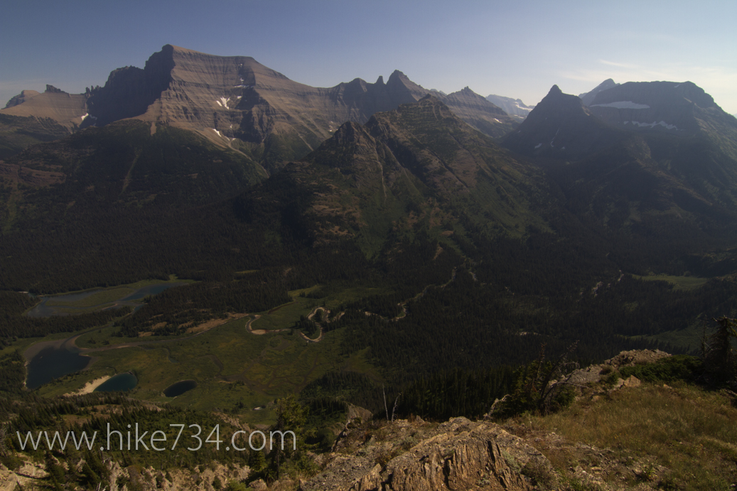
You finally make it to the top to amazing views. You can look up the Valentine Creek drainage for better views (even looking at the tops of Rainbow and Carter Peaks), but the real gem is the view straight ahead looking east from the lookout. Looking down on Kootenai Lakes, you get to see why it’s moose habitat heaven with the many smaller lakes and slow moving water… you can even spot the moose in the water. If you look north, you can see Waterton Lake and right across the valley you have Mount Cleveland and the Stoney Indian Peaks area.
Overall, not many people come up and visit this lookout because of its location, but that is the only reason to think twice about visiting it.
Comments
10 responses to “Porcupine Lookout”
I hiked up to Porcupine a couple decades ago, back before the building was restored and at a time when the trail itself was abandoned. The subdistrict ranger back then told me that my friends and I were the only people to make it to the lookout that year. It was a challenge, but man, it was a great hike!
That’s sweet! I’m thinking that I’m glad they redid the trail though. 😉 My guess is that it still doesn’t see too many visitors as it logistically a bit harder than other lookouts. Talk about views eh?
As you can imagine, I’m now an oldtimer. I was the lookout on Porcupine during the summer of 1957.
I enjoyed those terrific views for almost 3 months. It was quite lonely, but the experience was well
worth it. I experience many things while there and saw things that few people have the luck to see.
Had only one visitor during the summer. He was a middle-aged bachelor who was the Head Librarian at the Univ. of Mass. He spent the night with me, sleeping on the floor.. i had an old Army cot and a sleeping bag. I could tell you more wildlife experiences, but there would not be room here.
Should anyone be interested, feel free to contact me.
Ted MokryHello Ted! It’s taken me awhile to get back to you here, but what an experience!! Have you taken the time to write down your experiences? That was definitely one of my favorite lookouts.
HI Ted
I am an old Lookout from the North Cascades Park — I would love to read or hear about your experiences that summer…..wow !.. you consider dictating them to a recorder and having someone type them up — or just have someone shoot a video of you –talking about your time there…… bruce firelookout@gmail.com
Hike734,
My plan is to hike Porcupine from Waterton which would put me under a time constraint to get back to the water taxi the same day. I can’t see the cutoff trail to the Waterton river from the main trail on Google Earth. I also can’t see the trail north of Valentine Creek until it is at the base at 4800. How well marked is the trail junction and how hard is to follow the trail on the other side of the river? Do you have waypoints of the cutoff trail junction or the river crossing?
LukeWondering if you have addressed Luke’s comments above so we can find the trail and also if you have mileage/elevation from goat haunt?
Hello Kristin! So it is a regularly maintained trail. It would not be visible for some of it in the lower section from Google Earth because of vegetation. I would make sure you check with the park’s trail status page (which I try to keep the link accurate from my backcountry permits page (https://hike734.com/educational/backcountry-permits-of-glacier-national-park/) to see if they’ve cleared it yet in the spring. Also keep in mind that the fording of Waterton River is slow, but deep!
I’d love to know the trail length from Kootenai lakes to the Lookout or roundtrip from Kootenai Lakes. Thank you for the nice writeup!
You’ve got 0.3 from the campground to the Northern Highline, then 1.5 miles heading south to the Porcupine Lookout Trail, then 4.9 to the summit. So 6.7 one way or 13.4 miles round trip from your tent at Kootenai Lakes.
Leave a Reply