Your cart is currently empty!
Dawson – Pitamakan
—
by
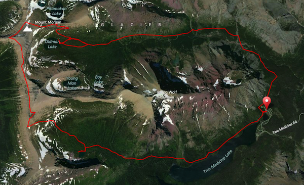
It doesn’t take very long to get out of the trees on the east side of Glacier National Park. The loop, known a Dawson-Pitamakan, that goes through two passes in the Two Medicine area rewards you with breathtaking views mile after mile. One access to the loop is by the Two Medicine entrance station known as the Dry Fork, however, most people will start at the campground over by Pray Lake and the foot of Two Medicine. Taking a right at the first junction will have you going towards Old Man Lake and Pitamakan Pass first, which is my preference. If you go this route, you have the opportunity to take a boat ride to shave off the last three or so miles (if you get to the dock by 5:20pm) or a level walk out on tired legs. If you choose to hike Dawson Pass first, you’ll hate the little climb up the ridge coming off of Rising Wolf at the end. We’ll pretend you are going the “right way”. 😉
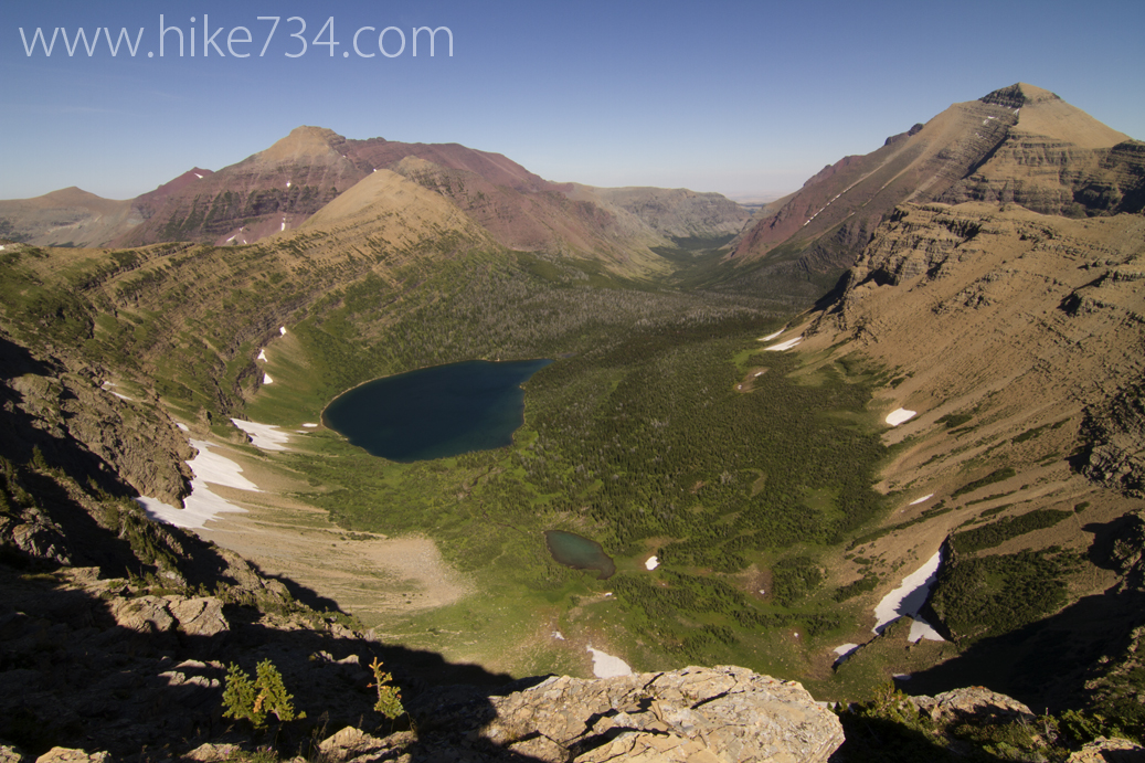
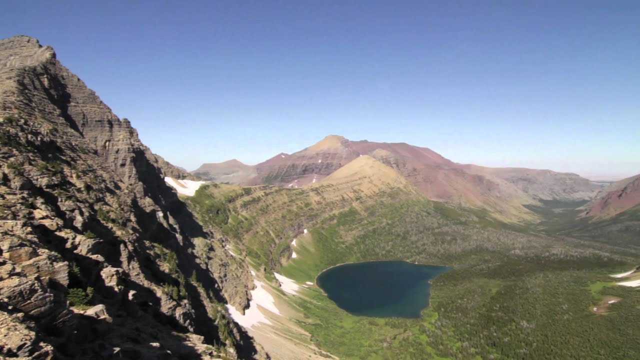
You work your way up Dry Fork and come to Old Man Lake which has old stands of silver trees giving it a cool and haunted feel. Grizzlies frequent the area, so be on the lookout. There area a couple of places to have lunch at the shores. From there, you’ll climb to Pitamakan Pass and see loads of wildflowers on switchbacks that gain elevation quickly. At Pitamakan Pass, you’ll have amazing views of Old Man Lake on one side and Pitamakan Lake (with a couple of other small lakes) on the other. On this north slope of Mt. Morgan, keep a lookout for bighorn sheep. I don’t think I’ve ever been hiking there and not seen them. The trail forks to Cutbank Pass which we’ll leave for another time and head on up to Pitamakan Overlook.
When you reach Pitamakan Overlook, you start to run out of adjectives and realize that you can still be impressed… even after what you’ve already witnessed. Before you lies the beautiful wooded valleys of the Nyack with hanging lakes in Martha’s Basin saying hello. Lifting up your eyes, you see a sea of peaks that silently states your insignificance. You’ll also want to have a jacket on as well, as the wind frequently blows so hard, it will try and knock you off your feet… literally.
The traverse over to Dawson Pass makes you feel like a Mountain goat and gets interrupted by the flat saddle between Mt. Morgan and Flinsch Peak that gives you an eagle’s view of Old Man Lake and the west face of Rising Wolf. Continue over to Dawson Pass, take one last look at the Nyack region and head on down into the Two Medicine area.
As you turn the corner, keep an eye out for more bighorn sheep as you head on down to No Name Lake. You can stop in at No Name Lake and look up at the cliffs off the side of Pumpelly Pillar and Mt. Helen to see if you can spot some Mountain Goats. From there, head on down to Two Medicine Lake. If you’re arriving before 5:20, you can take the boat, otherwise, you can enjoy the walk along the north shore of the lake and back to your car. You will be tired and satisfied.
note: There are campsites at both No Name Lake and Old Man Lake if you wish to break up this almost 19 mile long journey.
Comments
55 responses to “Dawson – Pitamakan”
-
This is one of our top three hikes in Glacier. We did it the “right way,” i.e. counterclockwise, and most of us made the boat, making it a fairly strenuous 15-mile one-day hike. The middle leg from Pitamakin to Dawson was not for the faint of heart, but had unbelievable views. The last 3 miles was relentlessly downhill and hard on the knees and toes. You didn’t mention that there aren’t any water sources most of the way so it’s important to carry lots of water.
Thanks for bringing back a great memory!
-
Gaaa!! Good point. So many things to remember! I almost always tend to get a late start hiking, so I’ve never actually ridden on the boat. Needless to say, I’ve hiked that north shoreline a few times. 😉
-
-
Hey Jake,
Great video! I had a really quick question about the Dawson-Pitamakan loop. Is there a lot of exposure on the loop? My wife and have done several trails in glacier but usually shy away from exposure if possible. We’ve done the Highline from Logan to the Loop and Siyeh Pass without any real problems but Mikes comment above kind of made us nervous about the trails exposure.
Thanks!
Ryan-
There is some exposure, but it won’t seize up those that are afraid of heights. It’s more goat trail and pay attention, but not “edge of cliff” if that makes any sense at all. What I mean is for a little bit after Pitamakan Overlook, you’re traversing a slope on a trail and it would be best not to step off as you’d be sliding, not falling. Worse case scenario is that you get to that point and decide that it’s too much for you, then you turn around and head back the way you came in…. but I think you got it. 😀
-
Thanks for the response! I’m pretty sure we’ll be able to handle that so we’ll add it to our trip itinerary.
Thanks again!
-
Sweet!! I would love to have you check back in and let us know if you were good with it. I’m really good with exposure, so my tolerances aren’t always everyone else’s and I LOVE getting other perspectives!
-
-
-
-
Hello. We have a group planning to do this loop next year first week of September. I’ve never done 19 miles in one day and am a little nervous about the distance and deciding which direction to take seeing some of our group of 10 has some knee issues but think leaving at 9:30 is too late if we take the first boat taking Dawson route first. Trying to decide whether to leave at daylight up Dawson up to the last pass and returning the same direction and catching a boat back or up Pitamakan early and catching the 5:20 boat. Any info would be appreciated.
Thanks!
Beth
-
I shot you a message!
-
Hi Jake!
First off thank you for sharing your knowledge with everyone. You are doing a great job!!
I have the same question as Beth. I plan to do this hike late August this year, preferably camping at Oldman Lake. I read that it’s great to do this hike counterclockwise if you are a photographer, which happens to be one of my interests. Could please share your thoughts on this?
Thanks!
Saurabh
-
I would agree with counter-clockwise for two reasons. The first reason is the least important of the two for me and that is, it allows you to shave off some distance by catching the boat at the end of the trip when you’d want it. The bigger reason is that I like how it reveals itself. In this way, you are always looking at great scenery while you hike. The walk out from Old Man Lake isn’t particularly inspiring (and features a little shoulder you need to go up and over that feels like an insult). Going the other way, however has you looking up the drainage towards the mountains where a lake eventually reveals itself. When you finish counter-clockwise, you’re walking along the shores of Two Medicine. If you spend the night at Old Man Lake, please send me a sunrise photo as I’ve never seen one myself from that lake!
-
Haha…
Thanks for your feedback Jake. I will surely try to get you that picture. I just hope I get a backcountry permit to camp at Oldman Lake.
Let’s see how it goes.
Cheers!
Saurabh
-
-
-
-
-
Incredible video and article! You have inspired me to do this hike one day! Unfortunately the only time I can make it to Glacier this summer is a little early in the season (June 20-24). Is there any chance this hike will be passable by then?
Thanks!
-
Hmmm, not sure how feasible. I might try and make it up there later on to see. I would keep a lookout at the trail status page to see when they get to it and what the conditions are. http://www.nps.gov/glac/planyourvisit/trailstatusreports.htm
Either way, you’ll have a great trip. There are still amazing places to go!
-
-
[…] next morning, Tim Young and John Gendron headed out for the fantastic Dawson-Pitamakan Loop and had a great day. After they returned back to Oregon, John put some of his photos together in a […]
-
Hey Jake, my wife and I are headed to Glacier (Two Medicine area) next week. We are thinking of taking the boat across the lake and then either hike to Upper Two Medicine Lake or up to Dawson Pass. We will be carrying our two daughters (1 and 3 yrs). How difficult is the trail from Two Medicine Lake up to Dawson Pass? We did Grinnell Glacier trail 3 years ago and thought it was very manageable, but we left the kids at home. Thanks for your thoughts. By the way, your site is amazing!
-
Well sorry for not getting to you sooner. This will probably be more of a “what did you end up doing?” kind of thing. Upper Two Medicine will probably be your better bet as a three year old gets wicked heavy and that Dawson Pass trail will make you sweat a little. 😉
-
Thanks for the info. We hiked in Two Medicine on Monday. We ended up doing the Twin Falls hikes with the little ones, and then I did the Dawson Pass hike by myself. I added the quick traverse between Dawson Pass and Pitamakan in order to see Old Man Lake. The views up there are unbelievable.
-
Yes they are! Nice work!
-
-
-
-
Hi Jake. Please tell me where you are at at 5:25 on the accompanied video – that looks incredible!
🙂
-
That’s the sweet goat traverse in between the Pitamakan Overlook and Dawson Pass. One of the reasons why this hike is in the top three!
-
The section from Pitamakan to Dawson pass that is the trail along the sloping shale I think I could handle (with my fear of heights) but that section at 5:25 referenced above looks pretty scary for me. How long is that piece and does it get any worse than the bit in your video?
and thank you so much for your great info.
-
Gosh, I can’t remember the length in distance. It’s not super long. I would say the hike up to Pitamakan Pass and the surrounding area to explore is worth the trip just in case you got up there and felt you couldn’t go any further. If that section was too much, you could turn around and call it a day… and it would have been an amazing one!
-
It is about three miles. It is not easy to turn around. Please see my comments from last year.
-
What I mean by “you can turn around” is that you get to the section where it is more exposed. If it looks like something you can handle, do it. If not, you can turn around before continuing on. There are a couple of more exposed sections on the Pitamakan side.
-
Jake, don’t want to beat a dead horse here but I’m thinking about doing this as a backpacking trip with my wife if I can get the permit to camp…For how long does it feel like, or literally is “you fall you die”? If it’s prolonged it’s probably something we can’t do…if it’s just a small section and I can convince her to be very careful in that section…maybe it’s something I could get her to do. Thanks.
-
-
-
-
-
-
-
Hi, Jake. Thanks for the video. It helps me remember our wonderful hike this past July (with my husband). I wanted to add that the “goat trail” portion of the hike from Pitamakin Pass to Dawson Pass really did bother me. I have done quite a few day hikes in Glacier over the years (this was my fifth trip there), including Swiftcurrent Pass, Siyeh Pass, and Grinnell Glacier, and this was the only one that gave me a sense of vertigo. I couldn’t really look out and enjoy the views along that section, sad to say. I just wanted to make it safely across. It wasn’t even super windy. I had to concentrate hard to keep fear from overtaking me.
A lot of the books and guides understate the information about this part of the trail. I think that it is important to know, so that one can make an informed decision. Other than that, it was a really fantastic hike. The views were stunning. For me, I would go up past Pitamakin Pass to Pitamakin overlook, and then come back the way I came.
-
Thanks for the great feedback! I need to reprint my map this year and I might see if I can fit some kind of language in there for that. It’s always nice to see something from someone else’s eyes. I’m glad you were able to overcome your fear and enjoy the other sections. 😀
-
-
Hi Jake, Wondering if you have gone or heard how this trail is after the closure last August due to fire? We were supposed to do this hike last year and are coming back in early Sept 2016. Thanks!
-
I haven’t gone or heard, but looked at the incident map and I think you’ll be just fine. The stretch that goes near the fire is all rocks anyway. You’ll get a good view of last year’s damage though!
-
Thanks!
-
-
-
Hi Jake! Would you recommend taking the boat in the morning? I read something that discouraged Riding the boat in the morning since you would get a later start. Would it be better to forgo a ride in the boat in the morning and possibly take the boat on the way back? How many miles does taking the boat shave off? Is it 2 miles each way?
-
I prefer the route through Pitamakan first because I like the way the route opens up as you hike it and then you can take the boat on the way out (if you get there by 5:20pm) which will shave 2 miles off. If you don’t make it by the time the boat leaves, you have a level walk out to your car along the lovely Two Medicine Lake. The other direction, people like because you can take the boat (giving you a later start) and you get all of your elevation out of the way early. The bummer is that you have an uglier last few miles coming out of the Dry Fork drainage and you have a little climb over a ridge that comes off of Rising Wolf at the very end which feels like a punch in the gut. Either way, the boat can save you 2 miles for the whole day, but not “each way” as it’s a true loop.
-
-
We did the hike the way you suggested and we were glad we did! Got an early start and were able to catch the boat back. Awesome hike! Thanks for your suggestion to hike it this way. Definitely one of my favorites in GNP. Love your site and can’t wait to explore more!
-
My cousin and I are planning this route (the “right way”) as a 3-day backpack at the end of July this summer, as long as our backcountry permit gets approved. Any additional tips about Oldman Lake and No Name Lake campgrounds? (ie: hard to find fuels, long hauls to water, etc.) We’ve both spent a lot of time in the park (she’s lived in MT all her life and I’ve spent summers there since forever), but this is the first time either of us is venturing into the Two Medicine area, and the first time either of us has backpacked in GNP. Thanks in advance for any extra info!
-
In regards to water, anything around there is at a lake, so no long hauls for water (bring a filter of course). No fires either, so finding sticks to burn doesn’t matter, (but make sure you have a backpacking stove obviously). Bring bug spray. Keep an eye up on the cliffs for mountain goats especially at No Name. 😉 (also have a great time!)
-
-
Can you give any idea of how much elevation on the last rise if walking out from Old Man Lake? (How many minutes walk is it to get to top of it at an average pace no stops?)
Do you find it a big of a drag having a continuous uphill walk most of the day when going clockwise? Doesn’t that start to wear on you? Also, descending so far so quickly must result in some pretty big blisters doesn’t it? (not to mention destroying your knees). thanks for the video, and all the helpfulness with answering people’s questions.-
It’s only about 100 feet, but it feels like more. You’re actually not going up most of the day… it’s just not all in one spot. The bigger thing for me is that it reveals itself in a much more interesting way. The downhill on your knees sucks regardless of direction. Others prefer it the other direction with valid reason. Just my opinion. 😀
-
“Just my opinion”. – And I GREATLY appreciate your opinion!!! Thanks so much for sharing your thoughts and insight. That was very helpful. I had gotten the impression that going counter clockwise it was uphill almost continuously, but just much more gradual, which I figured wouldn’t be nearly as hard on the knees. But if it’s almost as hard on the knees going either way, then that definitely removes one big plus mark for going clockwise. I did a lot of backpacking when I was younger, and with going down a lot of long steep hills, it really messed up my knees, so these days it doesn’t take a whole huge amount of punishment to really irritate em again and make things painful and difficult, so I’m a little apprehensive but REALLY want to go on this hike!!! We’re gonna be there in July.
Thanks again for your video and all the info.-
Regardless… it’s a big day. 😀
-
-
-
-
2 more questions! Can you PLEASE confirm what the actual total mileage of the hike is? I have seen so many different numbers given. Some say it’s a 17 mile hike if you DON’T take the boat and 15 if you do. Some say it’s 17 miles if you DO take the boat the last couple miles and 19 if you DON’T. Some say the boat cuts off 2 miles, some say 3 miles. ??? (And I read on the website for the shuttle across the lake that they don’t do one way fares across the lake except for the trip OUT. But from so many other comments it sounds like they DO. )
Everyone talks so much about how windy it USUALLY IS up near the passes. You mentioned it can literally try to blow you off your feet!! Isn’t that dangerous/scary when walking thru the exposed areas such as at 5:25 on your video?? Or when right up on top of the ridge? I would think you could easily be blown right off!
-
According to my calculation using my GIS software with the NPS data, it’s 17.9miles. From the junction with the trail to the boat, you have three miles of hiking or approximately one mile to the boat. You save a net of 2ish miles. I know people who have taken one way trips both ways.
As far as the wind goes, if it’s really bad, you turn around. I’ve done that once. I’ve also had it completely calm. The wind is usually worse near the passes, not along the goat traverse, but if it’s blowing hard as I approach the passes where I’m leaving my feet, I’ll turn around.
-
Thank you!! So, the 17.9 miles is total distance if you DON’T take the boat then? And rougly 16 miles if you DO take the boat?
I also wanted to ask – we are hoping to hike to the falls which I believe are called Running Eagle Falls (or Trick Falls), where you can see a falls comes out of a “cave” in the rocks if the water levels are low enough that the water is flowing over top of that cave from the higher falls. Do you come anywhere near this falls on the Pitamakin/Dawson hike? Or is that too far of a walk and needs to be done on a different day?-
Different hikes. Trick Falls is a level <1 mile hike. You might consider picking up my map. It is helpful in answering these questions as well. 😉
-
-
-
-
Wow, that’s awesome, thanks for mentioning that. I hadn’t noticed those were available, but i will definitely grab one!!
Not sure if this question is answered on your map or not, but I just gotta ask it. 🙂 What do people do when doing a full day hike and nature calls??? Many of the portions of the trail (ie on the Pitamakin/Dawson trail) don’t appear to have a lot of “cover” such as woods etc. Or especially on trails that are pretty crowded with lots of people?? (like Highline Trail etc).
(Is it just a “Go now or forever hold your bladder” situation when leaving the trailhead?)Lastly, in YOUR opinion, if someone is (mildly to moderately) nervous or afraid of heights (as a couple in our group will be), which in YOUR opinion would be the spots most likely to bother them – the goat trails, passes, or the kinda scary looking narrow ledges?? (On Pitamakin/Dawson hike). In the videos it would look like the narrow ledges could be the scariest, but sometimes it’s difficult to get a true perspective from a video. (for example, on videos of the early part of Highline Trail, the ledges (above the road) look pretty narrow, but on the park’s website I read some official info someplace which mentioned they are actually about 6 feet or so wide. DEFINITELY don’t LOOK that wide on video.)
Thanks again for all the work you have put into the videos, and now that I’m aware of the maps, for THOSE TOO!!
-
When nature calls, step off the trail and go. You’ll figure it out. 😀
If someone is afraid of heights, it’s wherever you have to walk where there’s a steep drop-off. That can occur in a few places. The goat trail traverse on the back side of the Dawson-Pitamakan Loop would be one spot where it doesn’t bother some people and other people, it’s a terrifying experience. The first part of the Highline often gets people as well. The nice thing about that one is that it’s at the beginning and, if you can handle that, nothing else is as bad on that hike.
BTW, your map is in the mail!
-
Thanks a bunch, looking forward to checking out GNP!!! And thanks for mentioning the maps, a great resource to know about.
Hey! How much water do YOU normally carry with you for Dawson/Pitamakin hike, since it’s a long ways between water sources? I know I’ve seem some OFFICIAL recommendations, but that’s a LOT of water/weight to lug around. Just curious how much you have found to be a good balance.-
I usually hike with something like 1.5-2Liters. Everyone is different though and it depends upon how hot of a day it is.
-
-
-
-
Love your videos! I have a quick question, and this may be redundant but I am going to hike this around aug 25 ish, and thinking about backcountry camping at old man lake and no name lake. Where do I get a permit for this? Can I get one at any of the ranger stations? I was thinking of entering thru Apgar first. Also I see a lot of suggestions to do this counter clockwise vs counter. What are your reasons to do pitamakin first vs Dawson?
-
It’s not the length of the question that is of concern, but the length of the answer. 😉
Look at my backpacking glacier page for info regarding obtaining permits. You’ll need a walk-in permit and the blog on that will be especially helpful.
I recommend counter-clockwise because I like the way that it opens up as you climb. There is also an annoying uphill section at the end if you do it in reverse. You can also catch the boat if you hustle. If you do it clockwise, you can start with the boat, but even if you don’t, the big advantage that others tout is that you get the majority of the elevation out of the way early and they’d rather climb up that section than come down on tired legs. Either way is the right way. My preference is counter-clockwise tho.
-
-
Thanks for posting about your experiences! As part of a late Aug/early Sept backpacking trip from St. Mary to Two Medicine, would you recommend following the Pitamakan Pass part of the trail (camping at Old Man Lake) or heading south via Dawson’s Pass (camping at No Name Lake)? Or more broadly, is there a better direction (north-south, south-north) for that trip?
-
So I would say, whatever gets you to do the traverse from Pitamakan Overlook to Dawson Pass. If you’re staying at Old Man Lake, but plan on going back up and going over to Dawson Pass, then really, either is great, otherwise, I’d do No Name Lake (going straight to No Name Lake will allow you to not lose elevation, then gain it again). Note, however, that the traverse is very exposed and folks with a fear of heights find it unnerving.
-
-
Hey Jake, what do you think would be a reasonable time to start this hike counterclockwise if we wanted to be at the boat by 5:20?
-
If I’m not birding/photographing/etc, but hiking, enjoying the scenery, noticing things, and having lunch, I like to divide the hike’s distance by 2 to get your hours, then maybe pad it with another hour. That means you’ll average 2 miles per hour with one for lunch. A good, steady pace is 3 miles an hour, but uphills slow you down and you can gain some of it on gradual downhills.
That being said, I would say give yourself 10 hours if you can. A 7am start feels right… although it won’t if you’re driving there from Kalispell. 😀
-
-
Hey Jake, I am planning to do this loop July 7-9. Do you expect considerable snow hazards still in place along the traverse from pitamakan to Dawson during this time of year? What are your suggestions if there is? Thanks.
-
Hi Jake, I love your site. You seem pretty well versed in this area of the park, wondering if I could get your opinion–we have a group of 3 50 year olds and six teens, the youngest being 12. She is tough and has hiked with us to Grinnell Glacier, Sperry Chalet, and up to Dawson Pass and back last year. We got a backcountry pass for Oldman Lake, and we want to hike into Oldman, sleep there, get up and head out by climbing up to Pitamakan, over to Dawson, and down to the boat on the second day.
Any thoughts on the feasibility of this plan?
Concerns–
1) heights/dropoffs. (We are okay though a bit uncomfortable with Highline trail type of heights)
2) Too much distance for the second day with backpacking equipment on our back.
Leave a Reply