Apgar Lookout

Apgar Lookout

Apgar Lookout is located right by the West Glacier entrance before you get to Apgar. If you come early season, the road is often closed by the horse corrals as McDonald Creek and the Middle Fork of the Flathead River are too high and over the road and the bridge (but usually safe to cross on foot). This will add 1.9 miles to your walk as it did to mine.

The trail used to be a walk amongst trees until it was all burned out and is now a walk through a burn area with lots of light and new growth. In the summer, it makes for a hot walk on this south facing slope. As far as lookouts in Glacier National Park, its grade is about a medium grade which means you’ll get a sweat on, but it won’t kill you. Snow lingers late into the spring at the saddle between the mountain and the knob where the lookout is located, but you’ll usually find tracks through it from others that have gone before you.

The lookout itself offers a nice view of Lake McDonald and Howe Ridge which you can preview by heading on over to the Park’s webcams by Clicking Here. The walk up gives you a sweet look into the Middle Fork and North Fork of the Flathead river confluence and surrounding communities.

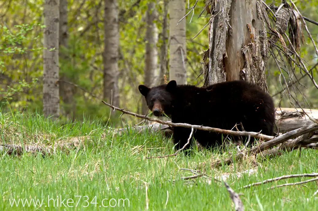
We had to walk along the road an extra 1.9 miles to get to the trailhead as the road was closed due to water being on it, but we made it to the Apgar Lookout Trailhead and hiked up to the lookout. While on the road, we saw a black bear (both going up and coming down) as well as some elk, so the extra walking was worth it as far as I was concerned!

In addition to the elk and bear, we saw some some squirrels, birds and flowers and a friend of mine proposed to his girlfriend. All in all, a pretty special day!

Had my mom snap a picture of Billy and I standing in front of the webcam. The Glacier National Park Conservancy is responsible for many of the webcams that give you views into the park from the comfort of your computer.

Apgar Lookout Webcam with Jake and Billy
Apgar Lookout
Black Bear

Get our sweet newsletter!

(and your free “10 Insider Tips for Glacier”)

Lists

Comments

7 responses to “Apgar Lookout”

  1. Mike Kinsella Avatar
    Mike Kinsella

    I like lookouts as destinations although it always means some serious elevation change. It’s worth it for the great views.I did some lookout duty myself. When I hiked to Scalplock Lookout, a friend of mine named Carol Savage was on duty- I thought that was appropriate, a Savage on Scalplock!

    I like the labels for the plants and animals!

    1. hike734 Avatar
      hike734

      Thanks Mike! I’m hoping that we can all learn a little more about the natural life. I’m having to go through and look up a lot right now trying to learn myself to teach others.

      I’m glad I was able to get some elevation finally. I’m not the biggest fan of just tree walking so the more the snow melts, the bigger my smile gets.

  2. Alysia Avatar

    I hiked the Apgar lookout once..worst hike ever. Finding the trailhead seemed nearly impossilbe. We parked down by the horse stable and walked the horse trails before we figured out we needed to go up the road. The hiking book I had listed it is a easy hike so I packed a hardly appropriate snacks of some crackers…you can imaging the look on my fiance’s face when we got to the top and were starving and I had only a bag of crackers. My favorite highlight of the hike was the company we met and hiked much of the way with. He was very friendly and we had a good conversation. He was so thoughtful he came back up the road and picked us up. He was just as zonked from the hike as we were. Some good memories but the view was just okay…for the amount of climb.

    1. hike734 Avatar

      I agree, it’s a bugger to find. I’ve run out of food on hikes before and that’s no fun. A practice I’ve started to do is put in a big ol’ emergency protein bar in my pack that is always there just in case. As far as mileage goes, the guide book I have says 2.8 miles, the sign says 3.6 miles… wait, what?! That’s a big difference! The actual GPS mileage is 3.46 with another 1.9 if you hike from the corrals. Glad you made it out and thanks for the warning to others! (I also think you should try it again with adequate food and starting from the trailhead… I think the view at the top will be better) 😉

  3. Your blog is great – will be following along through all of your treks. Have hiked in the park for the last 15 years and have never used a gps. Some of the mileage on these hikes just did not seem totally accurate so I plan on getting a gps this year. I have been checking out several different models but many of them say that if you don’t walk at least 3 mph then their mileage tracker may not be accurate. Would you please tell me what make and model you are using so I can check it out – Thanks Hopefully will see you on one of your hikes best of luck and stay safe

    1. hike734 Avatar

      I’m using a Garmin GPSmap 60CSx that my folks got me for Christmas. I’ve also got the Mapsource Topo on there which is very very hit and miss. I use it some for the trail itself, but mostly to see what I’ve done and to create the maps that I post in my summary blogs. The actual distances that I’m using for counting my miles out is from the Park itself to ensure that I get my 734.88 miles checked off.

  4. hike734 Avatar
    hike734

    I would loooove to, but I just don’t have the time right now to focus on that. Are you able to watch youtube videos on your phone? If so, you can visit my youtube channel and watch them there. If not, my blogs probably won’t be of a ton of value as most of them are heavily video blogs.

Leave a Reply

Your email address will not be published. Required fields are marked *

This site uses Akismet to reduce spam. Learn how your comment data is processed.